WELCOME to the Save the Long Island Motor Parkway site!
It was created to provide historic information and to organize support for preservation and conversion of the bulk of
this historic road into a recreational resource such as a hiking/walking/biking shared use bike trail, separate from auto
traffic wherever possible. We need to remain vigilant to prevent further loss of this potential greenbelt, since some of the
land could still be developed and lost forever. Nassau County formally hired a consultant in September 2009
to create a master plan for the entire former LI Motor Parkway and parts of the adjacent central RR Corridor within the county.
The Master plan is now complete, and was released at a news conference on June 3, 2011 by Nassau County Executive Ed Mangano. A
pilot project will create a trail link in the Eisenhower park area and will include a trail along Salisbury Park Drive, which itself
was part of the Motor Parkway. A new group, known as the LI Motor Parkway Preservation Society has been created, combining many
interested parties including the LI Motor Parkway Panel and LIGHT. The next project is to find funding for the rest of the trail!

There was major news coverage in the October 24, 2005 edition of Newsday, including detailed maps in the "fold" section.
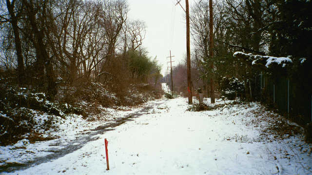
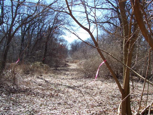
A crew of volunteers including Sam Berliner cleared the route of the parkway in Old Bethpage Village, Battle Row Campgrounds,
and Bethpage State Park a few years ago and much is easily walked or bicycled now. We rode on February 18 2008 when it was
only 15 degrees Farenheit, from Bethpage State Park to Eisenhower Park along the undeveloped Parkway and Central RR corridor. There was only ONE obstruction along the entire route!
Thank you for all of the support over the years. Nassau County was once planning to sell many small parcels that include portions of the original right-of way for the parkway but will now hold on to all properties related to the parkway. In fact a disputed segment in Levittown was sold to a developer and they have been trying to build huge homes on it, potentially dooming part of the trail in that spot. However, the builder was never able to get approvals from the town and hopefully will sell the lands back for a reasonable price. We do have a bypass already planned along the Central RR corrridor if that should fail. A critical need is to save Deadman's curve in Bethpage. It may be town or county land but it could be sold off if we do not act to save this historic engineering marvel.
We are now working with Parks and Trails NY (PTNY) and also have support from the LI Greenbelt trail
conference and other groups to preserve these historic corridors. PTNY has chosen the Motor Parkway as one of its Key LI
projects, and is meeting with our committee, including the consultant team, community groups, and local officials to
further the project and gather citizen input.
We also have formed a new group, Coalition for LIGHT (Long Island Greenways and Healthy Trails) to work towards the
fulfillment of this goal. LIGHT will operate as a subgroup of CLIMB (Concerned Long Island Mountain Bikers). NYS parks
has decided to reuse the Bethpage state park segment as part of the already funded Bethpage Bikeway extension.
Much progress in cleaning up the segment in Old Bethpage Village, including the historic bridge, was done by the Model
A Ford Club and some LI Motor Parkway Panel volunteers. More work was also done in Bethpage State Park and Battle Row
Campgrounds. You have to see this... the old road unearthed after all this time is STILL in very good shape where bulldozers
never attacked it! The Old Bethpage Village Reservation bridge still supported the weight of a county bulldozer,
so hopefully it will pass engineering inspections too. Huntington Town has expressed new interest in its portion of the
old road, hoping to get a trail easement on sections near Bagatelle road, preserving the Maxess road bridge abutments
with the help of an adjacent landowner and placing a historic sign nearby on Maxess road. Huntington also supports the
trail leading from the Edgewood Preserve, rebuilding of the now-demolished bridge on Commack road and then a trail along
the LIPA transmission right-of ways to reach the extant LI Motor Parkway in Melville
Slowly but surely good things are beginning to happen. It is VITAL that all remaining LI Motor parkway roadbed and
historic structures such as remaining bridges and posts be protected and preserved. The goal to create a bike and
walking path should not only preserve what remains, but repair and stabilize it. Where road sections have been
obliberated, a new path could be constructed to mimic and follow the old road as much as feasible, using adjacent right
of ways, and even local streets where this is no longer possible. There has been, and remains, a lot of competition for
project funding. We can suceed only if people continue to support this goal. We had some visitors here in January 2003
and again in May of 2004 who toured the entire length from Western Suffolk to the Queens line and were impressed with
the idea of saving it as a walking and/or bike trail. Furthermore, NYDOT has created "Corridor 16" which is the proposed
Edgewood Preserve to Eisenhower park route in their long term plans. Only the portion from Edgewood to Bethpage state park
was prioritized but lost the status again as liability concerns became an issue. This is just a MINOR setback in our
humble opinion since there is still strong local and regional support. Please write to your state and local legislators
and officials and also contact the DOT staff, the National Park service and join
www.ptny.org and show some support if you have a few moments,
LIPA has agreed to consider supporting this too and is helping determine ownership of the Right Of Way. They are of course
concerned about liability themselves so we must find a way to insure the route or determine if the NYS recreational use
statute will indemnify LIPA and the local towns and counties from lawsuits. Any FREE legal expertise on this issue is
certainly appreciated! We have been waiting to hear back from the MTA who owns the abandoned Central Branch ROW used by
LIPA. Nassau County has hired the engineering consulting firm VHB Associates to create a master plan for the entire Motor Parkway route within that
county. This master plan is very thorough and now completed.
with them, PTNY, the county, the towns and LIPA to move forward... The time to get it started is now!
The first priority is to get the various government entities who control the remaining right of way to agree on a preservation plan and then possibly a hiking trail so that development does not erase more of this historical road. Segments that are being used by LIPA are probably not in immediate danger, but the rest can be destroyed due to lack of any preservation plans. I have contacted Huntington town and copied the tax maps to determine who owns the Right of way (ROW) in the western Suffolk area. We have requested open space evaluation by the town, and others have begun to look into open space acquisitions in Babylon town also. The Maxess road old bridge area is endangered. Old Bethpage Village recently began cleaning up it's road footage and remaining bridge after we requested some action, and we are working with Bethpage state park also. If anyone has knowledge of any ROW that is in imminent danger of being developed please pass it along to us. A hiking trail can easily be created with volunteers who can get together and cut down some overgrown areas just to make it accessible and hikable. In areas where it is appropriate, bike paths can be added later, such as along the LIRR central where the ROW is wide and the parkway ran parallel.
Creating a network of recreational trails for bicycles, walkers, joggers, rollerbladers, and anyone else who enjoys the outdoors in a non-motorized transportation you can think of is essential. Please consider supporting these goals so we can avoid getting in the car just to travel a mile to the local park or strip mall. These projects include creating such trails from Belmont Lake to Babylon Village, a 13 mile trail along Ocean Parkway from Jones Beach to Captree and eventually Robert Moses Beach, another connecting the Edgewood Preserve via the old bridge on Commack and over to Eisenhower and the rest of the Motor Parkway. Perhaps even adding trails along the Sagtikos Parkway and Robert Moses Causeway to the beaches! Also, an extension of the Bethpage parkway bike path to Syosset, another 12 mile route along the abandoned LIRR Wading River branch, and of course my favorite, restoring the ENTIRE remaining LI Motor parkway, (AKA Vanderbilt parkway) as a recreational path running from Western Suffolk to Queens, where the bike path already exists. It's hard to get people motivated to support these projects, and there is always one local resident who fights it tooth and nail because they feel an increase in crime will come with the "outsiders" coming through. However, in other areas where such trails have been built, home values INCREASED and crime decreased, it actually improved the quality of life in the area and created a park like atmosphere in these areas where it was safe for local children to play away from motor vehicles.
It's much more relaxing and fun when you can go out for a ride or walk and not have to deal with traffic clogged roads, diesel fumes, inconsiderate motorists and noise. The ribbon park and extended greenbelt open space concept is one whose time has come. Please support these plans by checking off the boxes on the form, and speaking in favor of them whenever possible. Anyone interested in supporting any of the bikepath projects should visit the The LI Motorparkway site , The Rail-Trail site, and The Old Bridgefor more info and let the powers that be know of your support!
We were attempting to save the old bridge that crossed Commack road in Dix Hills rebuilt about 1 mile south of the
LIE. It was NOT related in any way to the Motor parkway, but did connect a vital hiking and bike trail that ran over it
and a replacement could EASILY connect to the LI Motor Parkway trail in Melville. Sadly, Suffolk County DPW demolished it in June 2009,
although we certainly tried to convince them to save it. They admitted renovations may be CHEAPER than demolition but
insisted that the lanes below must be widened. It was built in 1941, 3 years after the LI motor parkway closed, to service long-gone farmlands
of Pilgrim State Hospital.
Please contact your state and local officials, the DOT, local historical societies etc,
and let them know about these valuable resources and their potential uses before they are gone forever.
We need your support to get this vital project started. Please e-mail me for more info! Have a great day and be sure to
come back soon... be sure to visit other panel members sites listed at the bottom of the page!
 LI Environment site
Hike-LI.com- LI Hiking info
Pedalpushersonline.com
Sam Berliner III's LIMP site
site-mail denisbyrne@yahoo.com
LI Environment site
Hike-LI.com- LI Hiking info
Pedalpushersonline.com
Sam Berliner III's LIMP site
site-mail denisbyrne@yahoo.com 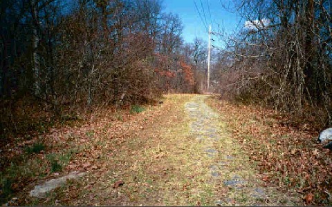

The Long Island Motor Parkway was the first concrete
limited access highway in the world. It was open to public as toll road, no trucks were allowed and also was the site
of the Vanderbilt cup races in the early years. It ran from Queens, starting at Horace Harding Blvd. at 199th street,
went thru the Kissena park and Cunningham Park/Alley Pond park corridor, headed east into Nassau County around Creedmore,
cut thru North Hills,New Hyde Park, Albertson, headed south towards the Garden City and the Roosevelt Field area,
then East again through the center of Long Island, cutting through Eisenhower park, Levittown, over to Bethpage state
park, into Old Bethpage Village, across the Suffolk County line, cut through Melville, crossed Rt. 110 a few feet North of
Spagnoli Rd, ran just South of the huge US postal facility on Rt 110, crossed Maxess Rd and Pinelawn Rd right at the
Newsday facility, generally followed just south of Colonial Springs Road, turned North across from the Wheately Heights
stores, and crossed today's Bagatelle road just a little to the north.
It ran just east of Bagatelle up to LIE area, turned right through the 5 towns college property, and came out right where
it still exists as a road starting at Half Hollow Hills Rd. and all the way east to Lake Ronkonkoma, where it ends,
then and today. A restaurant named Petit Trianon, commissioned by William K. Vanderbilt and designed by William Russell
Pope, was located at the Lake. It burned down in 1957. Sadly, in 2006, the remaining workers dormitory, a wonderful
structure designed by the same man, which had been converted into a nursing home, was demolished by a developer.
They eventually wanted to build it all the way East to Riverhead but never succeeded. The road was only 16
feet wide and had NO speed limits initially. In 1930 when the Northern state parkway was constructed, usage dropped off on
the LI Motor Parkway due to the tolls (this was during the great depression) (2 dollars, dropped to 1 dollar and eventually 40 cents but the Northern was free!) They tried to widen and modernize the road in 1926 but still ended up losing money, eventually turning it over to the counties
for back taxes in 1938. Most of the road and bridges soon fell into disrepair, and as modern roads were widened the old
bridges were demolished to make way.
For various reasons, including the fact that master builder Robert Moses thought the Motor Parkway was
"a white elephant" , the counties of Nassau and Queens decided to close the road to auto traffic.
Queens planned well and kept the road in use as a bicycle trail in Alley Pond and Cunningham park. Suffolk kept most
of its portion of the road in use, known today variously as Vanderbilt Parkway and Long Island Motor Parkway. Nassau sold
most of it's portion to LILCO for a powerline right of way, and some was sold off locally. A lot of the rest is forgotten
behind shopping centers, inside parks, and in use as different local streets. Though some has been lost to development,
and nature has also reclaimed a lot, we must act now before more is developed. Major pieces still exist and although it may
have to be rerouted slightly where homes were built on the land, easements could be obtained from commercial, industrial,
and apartment facilities.
We added a logical extension along a LIPA route from the eastern part of Dix Hills at the Edgewood Preserve. This is to
create a wonderful destination at the eastern end and join the parkway route at Bagatelle Road. There is a good amount of
road Dix Hills off just Bagatelle and in Melville (LIPA ROW). It could be joined to the part in Old Bethpage Village,
there is room to fit a path somewhere off Spagnoli Rd, perhaps behind the industrial bldgs near or on the actual ROW.
Then, it could join the Bethpage State park segment and the bikepath there, go on thru Levittown, intersect with the
Wantagh parkway bike path, and go to Eisenhower Park. From there to the Roosevelt Field area might be a little harder,
but something could be improvised on or near the ROW. Once you get to the section near Raymond Court, the ROW returns
as a possible route. There are some obstacles in Garden City, but heading north once you get cross Old Country Rd. there
is some ROW again, but a bridge over the LIRR would be needed. Then on to Albertson, New Hyde Park, and Manhasset Hills,
more exists, so there is also a chance to preserve this area. Some of it is in private yards, so existing nearby public
roads could be used where too much development has blocked access.There may never be enough money to get new overpasses
built for a bike/ hike route but at least the roadway and old bridges might get saved. We also have to keep pressure on
Nassau as they are not in good shape financially and may attempt to sell off ROW
Much of the road was built without stop signs or traffic lights, although a few grade crossings did exist, mostly in then
rural Suffolk County. They used over 60 bridges to avoid the need for intersections, several remain today, but most were
demolished due to the fact that they were too low and narrow by modern standards. Teams of mules were used to raise steel
and concrete. Land for right of way was often donated by landowners who were promised that property values would increase.
Some refused to sell at any price.. when someone refused, the road was simply rerouted. That is why the route twists
and turns so much all over its original 45 mile path. We are trying to get the bridge portion in Old Bethpage Village
preserved. The county, The LI Motorparkway Panel, and the Model A FORD Club has begun cleaning up the area, clearing brush
and debris, and we REALLY should say thanks... come out and see the progress! Parts were long used as a dump. The bridge
should be inspected to determine it's condition soon. And the NYS parks commission has been notified of our goals for the
portion within Bethpage State park.Thanks to many volunteers and NYS and NC parks, the ROW inside both Bethpage State Park
AND Battle Row Campgrounds is now easily walkable and accessible. You have to see it! A bike path may eventually become
possible from Bethpage State Park following the ROW over to Eisenhower park and connecting the Bethpage bike path to the
Wantagh bike path. And an eastward extension to the Edgewood/Sagtikos area. We need to get a committment from as many state
and local officials as possible to preserve and reuse as much of the remaining ROW as possible as walking paths or bike
trails before time and "progress" erase more of our local history. Also, getting more support from residents and other
groups, etc.